It’s hard to plan a trip to somewhere before you know how big it is and how hard it will be to get around. Scroll down to see Tokyo’s main subway line superimposed on your city’s map!
Anyone who wants to be somewhere on time in Tokyo takes the train. They’re not just frequent and fast, they’re scarily on time. For example, this is the Yamanote train line, which runs in a ring around central Tokyo, and is ridden by an average of 2 million people per day.

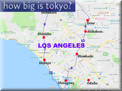
I’ve highlighted some of the biggest stations in the circuit (plus Odaiba, since it’s such a popular destination). Here’s how far apart they are on a regular map:

And here’s how many minutes it takes to go between the highlighted stations if you’re riding the train:

To give you a better idea of how far and how fast, here’s how the Yamanote Line would look in other cities around the world, and how long (in minutes) it would take to get between stations (apologies if I didn’t pick your city – I had to draw the line somewhere!):
BERLIN

CAIRO

CHICAGO

DELHI

LONDON

LOS ANGELES

NEW YORK

PARIS

SAN FRANCISCO

SAO PAOLO

SEATTLE

SHANGHAI

STOCKHOLM

SYDNEY

I’d be very interested to hear whether these distances/time to get somewhere seem short or long to you. After living in both Tokyo and San Francisco, where traffic is a nightmare at all hours of the day, when I compare the time in transit to going a similar distance in a car, it seems hella fast to me!
The Yamanote line is just one of the many train lines that make getting around Tokyo faster, easier and cheaper than driving or taking a taxi. And the main reason is traffic. Here are two Navitime Japan Travel app search results for getting from Shinjuku Station across town to the delightful and popular neighborhood of Asakusa. The one on the left is for arrival at 9 am, the other for arrival at 11am:
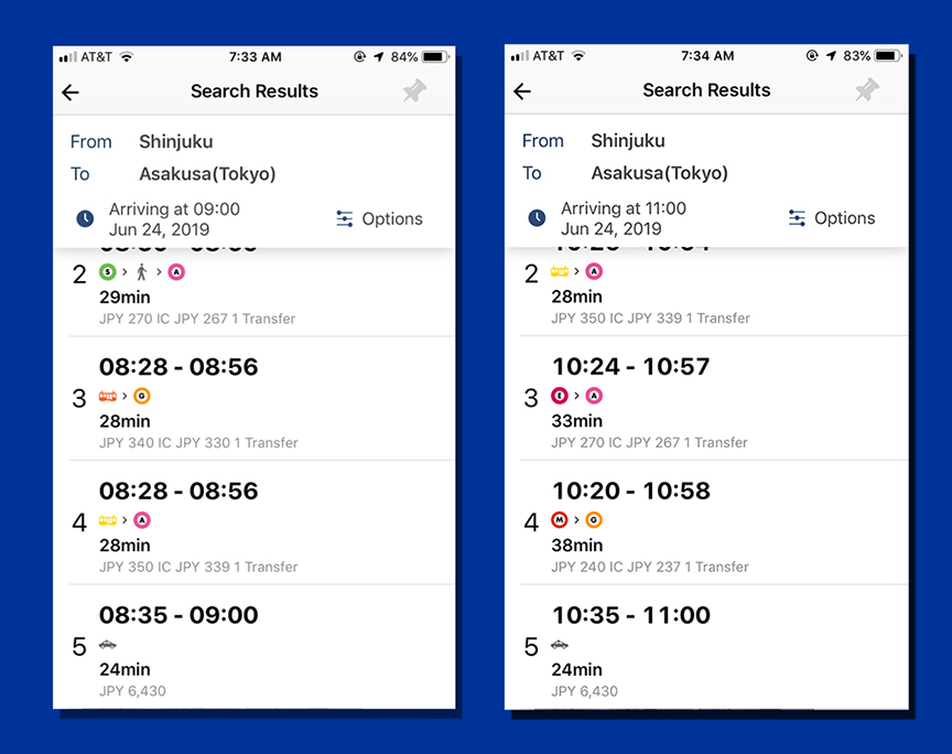
Note that the train routes vary in length and which trains they recommend, depending on whether it’s rush hour (left) or not (right). The one thing that doesn’t change is option #5, the taxi time and price estimate. That’s because they don’t take traffic into account. In a parallel universe, where you are the only one on the road (ahahahahahaha), you would get there in about 24 minutes. But that never happens. Trust me when I say that even if you spend over ¥6000 instead of less than ¥400, you will not get there faster if you take a cab.
Get more Japanese goodness straight from the source!
Subscribe to my monthly Japanagram e-magazine・° ♪・☆ It’s free!


Japanese Home Cooking recipes • Beyond Tokyo travel destinations • Seasonal Secret shopping & events • The Thing I Learned Today • Why, Japan, Why? • Monthly book or J-swag giveaway
•

Jonelle Patrick writes novels set in Japan, produces the monthly e-magazine Japanagram, and blogs at Only In Japan and The Tokyo Guide I Wish I’d Had

A little inconsistent with use of Tokyo’s population against other cities. For all cities you have used metro population (some outdated fir example Sydney has been over 5 million for years and the number you quote is from well over 20 years ago). I’m this respect it’s well know that although Tokyo is the only mega city in decline, it’s still in 2023 considered to be 36.5 million for the greater Tokyo area. The greater Shanghai population you refer to though is quite accurate (only a couple of years off).
Love the maps!
Wow, thank you for that call-out on the wrong numbers! This is an old post, but that’s no excuse for comparing apples to oranges (why did I do that? ugh) And honestly, by now, all the city numbers are becoming more and more inaccurate, so I think I’ll take down the city graphs and just keep the train maps—those a more fun way of giving people a feel for how big Tokyo is compared to places they’re familiar with, anyway! Thank you for the prod to make this post better!